
An osprey is ringed (banded) by the Rutland Ospreys project
You have probably seen birds with bands on their feet. These tiny metal bracelets may be colored and labeled with letters and numbers, all of which can tell scientists a lot about the bird, including where it is from, when it was born, and what gender it is. But you have to either catch or see the bird (usually with binoculars) to gather this information.
Today, GPS transmitters are attached to almost anything, from butterflies to bears, to learn more about the animal’s habits. We now know more about osprey migration routes, including where they go, how long the trip takes, and where they stop to rest. When the osprey has reached its destination and settled in to raise a family, the GPS can tell us how far the bird travels to find fish each day. This in turn gives us a clue about the health of the environment. Is the river near the nest flooded and murky? Must the osprey travel further to find a clear pond or stream for fishing? Why?
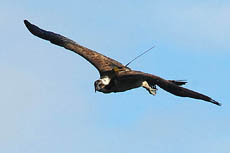
Pete is a Finnish osprey outfitted with GPS
But how do you attach a GPS transmitter to an osprey? Very carefully. The transmitter is secured to the bird’s back with a lightweight harness that allows free movement of its wings. It’s not a giant backpack – the transmitter itself weighs about 30 grams, and newer ones are only 5 grams. It’s a tiny, but very expensive piece of technology, costing about $5,600 CDN.
The transmitter has a unique identification number, which can be assigned to the bird wearing it, and can be calibrated to take readings as frequently as desired. It records the bird’s speed, altitude and course and transmits this data every few days via satellite. A solar panel keeps the transmitter charged.
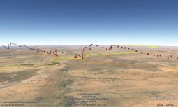
The Highland Foundation for Wildlife tracks ospreys migrating from Mauritania to Scotland
Once scientists receive the data, it can be plotted using Google maps. This perspective of an osprey’s migration track over Senegal/Mauritania and the Sahara Desert shows her altitude as she climbs using thermals. A thermal is an upward current of warm air. Riding thermals helps the osprey conserve energy during her long migration, reaching an altitude of about 2000 metres (7000 feet) at the highest point here. A transmitter is expected to last about 7 years. Once its battery expires, it will fall off the osprey.
For more detail on how an osprey is fitted with a GPS transmitter, have a look at an interview with Roy Dennis MBE, the head of the Highland Foundation for Wildlife, at Audubon.org
